Introduction
The Atlantic Coast Pipeline, LLC, (ACP) is a new underground natural gas transmission pipeline project that is proposed to run approximately 600 miles through West Virginia, Virginia, and North Carolina (“Atlantic Coast Pipeline to Build $5 Billion Natural Gas System,” 2015). In August 2016, the Federal Energy Regulatory Commission (FERC) established an environmental review timeline that included the delivery of draft and final environmental impact statements (EISs) required by the National Environmental Policy Act (NEPA). One of the purposes of EISs is to provide a “full and fair discussion of significant environmental impacts and … inform decision makers and the public of the reasonable alternatives which would avoid or minimize adverse impacts or enhance the quality of the human environment” (40 C.F.R. § 1502.1, 1978). The draft EIS was prepared by FERC and released in late December 2016, marking the start of a 90-day public comment period. The final EIS was published in July 2017.
Since 1997, existing federal guidance (Clinton, 1994; Council on Environmental Quality, 1997) indicates that EIS documents should address environmental justice in minority populations and low-income populations. To help achieve this goal during the NEPA process, the Federal Interagency Working Group on Environmental Justice established the NEPA Committee to “improve the effective, efficient and consistent consideration of environmental justice issues in the NEPA process through the sharing of best practices, lessons learned, research, analysis, training, consultation, and other experiences of federal NEPA practitioners” (US Environmental Protection Agency [EPA], 2016b, p. 6). The NEPA Committee’s recently published Promising Practices report provides researchers with examples of methods that are used to consider environmental justice during NEPA processes (US Environmental Protection Agency, 2016b).
In the spirit of the Promising Practices report, we developed this report, which describes quantitative methods local communities may find useful for evaluating environmental justice concerns with respect to pipeline projects. Our basic methodology compares the characteristics of census blocks, block groups, and tracts that lie within a 1-mile zone of the proposed route with corresponding census geographies that lie outside of the 1-mile zone. We have conducted the analysis for two counties (Northampton and Robeson) that would be affected by the proposed ACP.
Rather than focus on the environmental impacts of the pipeline itself, our study looks at preexisting characteristics of communities that would be in the path of this infrastructure project. We evaluate whether ACP would disproportionately burden certain groups of people more than others, simply by virtue of its alignment. Natural gas pipelines and appurtenant pipeline operations facilities can impose a variety of environmental burdens on the communities that they cross. Potential impacts include: visual impacts; adverse effects on sensitive flora and fauna; damage to water supply sources during construction activities;1 intensive water usage during construction; wetland impacts (primarily during construction); forest fragmentation; noise impacts from compressor stations and meter and regulating stations; air quality impacts and related health concerns resulting from compressor station emissions; land use restrictions for properties crossed by the pipeline; and increased risk to life and property from pipeline explosions (D. Brown et al., 2014; D. R. Brown et al., 2015; Federal Energy Regulatory Commission, 2016; Macey et al., 2014; Smith, 2015; US Department of Health and Human Services, Agency for Toxic Substances and Disease Registry, 2016b, 2016a).2 Through various mitigation efforts, these impacts can be reduced, but not entirely eliminated. At a minimum, a community that hosts a pipeline faces heightened risk of accidents during construction and operation.
Although none of the ACP’s potential impacts would directly alter the demographic or environmental characteristics examined in this study, our results provide valuable contextual information for evaluating whether potential impacts are equitably distributed. Our approach aligns with the NEPA Committee’s recommendation to compare the general population’s exposure to adverse impacts with the exposure of minority and low-income populations (US Environmental Protection Agency, 2016b). Impacts that are “predominantly borne by minority populations or low-income populations” may be disproportionately high and adverse (EPA, 2016b, p. 46). In considering preexisting environmental burdens, this study also responds to the NEPA Committee’s call for scrutiny of any impact that “occurs in minority populations and low-income populations affected by cumulative or multiple adverse exposures from environmental hazards” (EPA, 2016b, p. 46).
In addition, our study offers the following benefits:
Uses publicly available census data that can be easily accessed on the Internet
Employs simple classical statistical methods
Makes available our computer code for external review and replication
Uses new environmental and social vulnerability data not considered in the ACP’s draft EIS.
The analysis in this report is designed to be shared with all interested parties to establish a common understanding of demographic, environmental quality, and vulnerability data and the analytical methods used to understand environmental justice.
Methods
To start the analysis, we acquired maps of the proposed pipeline route through Northampton and Robeson Counties from Atlantic (the pipeline company) on October 19, 2016, and November 17, 2016, respectively (Dominion, 2017). Using a geographic information system (GIS), we geo-referenced the pipeline route maps and created a GIS shapefile of the pipeline for each county. The proposed location of the compressor station in Northampton County was added to the GIS in the same manner.
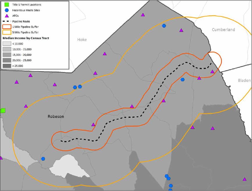
Next, to identify populations that live near potential impacts, we mapped a 1-mile “study zone” around the proposed pipeline route. The selected distance is the same distance FERC (2016) uses for demographic analysis. A review of recent compressor station impact analyses also suggested that a 1-mile distance was appropriate for capturing the area that could be affected by the proposed Northampton County compressor station (D. Brown et al., 2014; Madison County Department of Health, 2014; US Department of Health and Human Services, Agency for Toxic Substances and Disease Registry, 2011, 2016b). The zone was then overlaid with census geographies (blocks, block groups, and tracts) to determine which geographies are located wholly or partially within the 1-mile area. Appendix A provides maps of the 1-mile zone and selected census data sets.
In the last step before the quantitative comparisons, we collected income, race/ethnicity, and vulnerability characteristics at various geographic scales: census blocks, census block groups, census tracts, and counties. Tracts are composed of census block groups, each with a population of between 600 and 3,000 people. Census block groups are, in turn, partitioned into census blocks, which are the smallest geographic boundaries defined by the census. Census blocks are defined using landscape features and property or legal boundaries (Rossiter, 2011; US Census Bureau, 2012a, 2012b).
To determine whether there was a statistically significant difference between income, race/ethnicity, and vulnerability characteristics for geographies within the 1-mile zone relative to geographies outside the zone, we used common classical statistical methods such as comparison of means with t-tests. For comparisons of mean household incomes, we had to perform additional steps to account for sampling errors associated with the American Community Survey (ACS) by calculating test statistics using the following equation provided by the US Census Bureau (n.d.):
Z = (A - B) / ([SE(A)]^2 + [SE(B)]^2)^(½),
where
Z is the test statistic,
A is the mean household income of census tracts (or block groups) lying within the zone,
B is the mean household income of census tracts (or block groups) lying outside the zone,
SE(A) is the standard error of the mean household income of census tracts (or block groups) lying within the zone, and
SE(B) is the standard error of the mean household income of census tracts (or block groups) lying outside the zone.
Income Data
Appendix B provides ACS 2010–2014 5-year data estimates for aggregate income. The draft EIS reports median income data and the total percentage of the population living below the poverty level (FERC, 2016, Appendix U). For both variables, however, FERC omits the standard errors that the ACS uses to measure the difference of a sample estimate from the average of all possible samples. Because some of these standard errors are large relative to the sample estimate (see Table 1), researchers need to acknowledge the uncertainties associated with sampling and how they influence FERC’s analysis conclusions. In addition, when making group comparisons and performing statistical tests of differences, researchers must consider standard errors when performing certain calculations for statistical tests.
Table 1.
23008Income and poverty data, as reported in ACS 2010–2014 5-year estimates for census tracts within 1 mile of proposed pipeline route
Note: All dollar amounts are in 2014 US dollars.
Source: US Census Bureau (2014): Tables B06011 (median income columns) and C17002 (poverty-level columns).
Race/Ethnicity Data
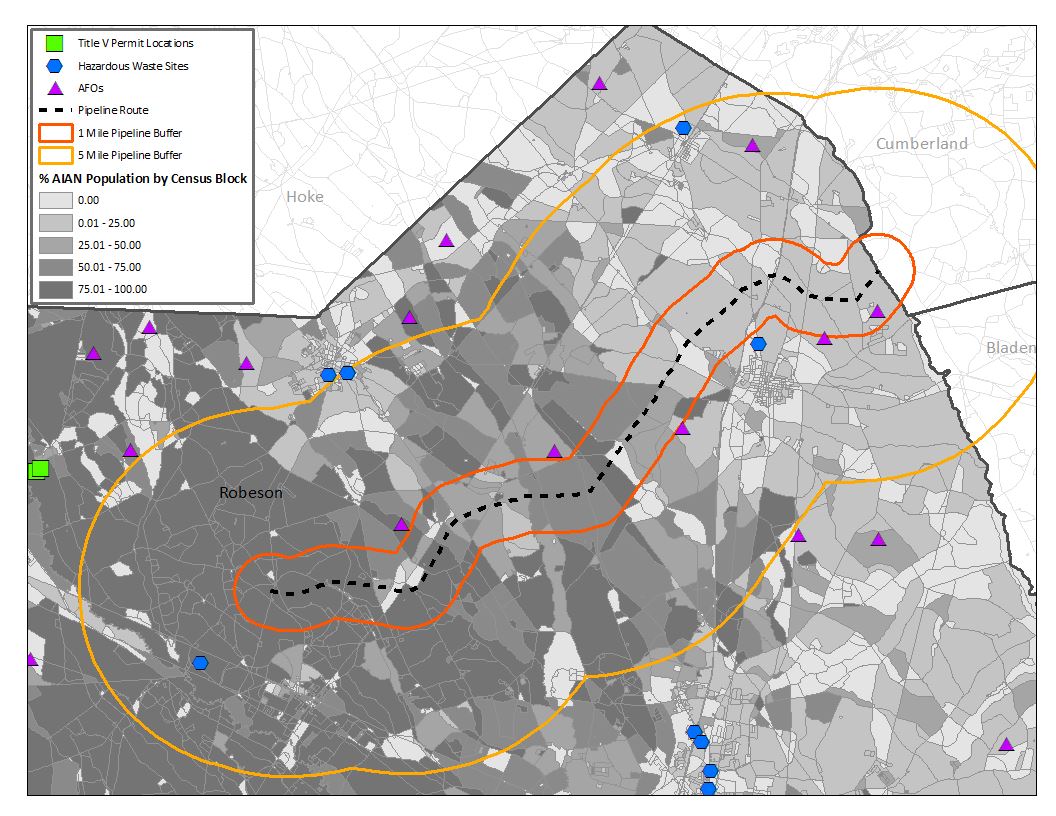
We downloaded 2010 decennial census block-level race and ethnicity data (Table P5, Hispanic or Latino Origin by Race) from American FactFinder (US Census Bureau, 2017). Because census block-level data are only reported for the decennial census, these were the most recent data we could obtain. We examined three variables at the census block level: black or African American, American Indian and Alaska Native (AI/AN), and Hispanic or Latino. The US Census Bureau considers “Hispanic or Latino” to be an ethnicity and the other two variables to be races. Because the US Census Bureau’s definition of ethnicity overlaps with race identity, some of the individuals who were included in our analysis of “Hispanic or Latino” populations were also included in our race variable analyses. Although analyzing each demographic group separately provides a more detailed picture of the populations that are affected by the proposed pipeline route, the potential for double-counting precludes composite analyses of those data. For race variables, we excluded data from individuals who reported multiple races; we counted only individuals who identified as AI/AN alone or black or African American alone. Tables 2 and 3 present descriptive statistics for race and ethnicity data for each county as a whole, as well as population tallies inside and outside the 1-mile zones. Figures 1 and 2 illustrate the population distribution of the largest demographic group in each county: black or African American (Northampton County) and AI/AN (Robeson County).
Table 2.
23009Census block race/ethnicity data for Northampton County, by zone
Source: US Census Bureau (2010).
Table 3.
23010Census block race/ethnicity data for Robeson County, by zone
Source: US Census Bureau (2010).
Figure 1.
23020Percentage of black or African American residents, by census block, the proposed pipeline route and zone, and selected facilities of interest in Northampton County
Sources: US Census Bureau (2010); North Carolina Department of Environmental Quality (2016a, 2016b); North Carolina Division of Waste Management, Hazardous Waste Section (2016).
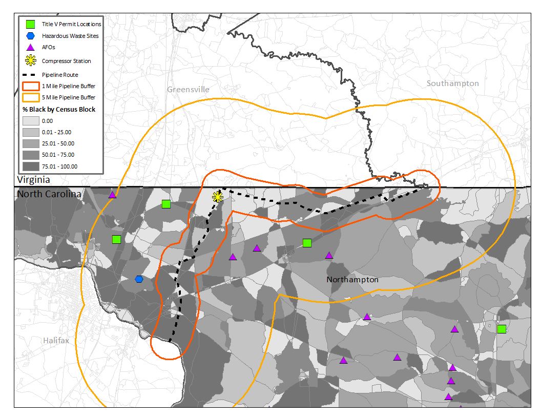
Figure 2.
23019Percentage of American Indian and Alaska Native residents, by census block, the proposed pipeline route and zone, and selected facilities of interest in Robeson County
Sources: US Census Bureau (2010); North Carolina Department of Environmental Quality (2016a, 2016b); North Carolina Division of Waste Management, Hazardous Waste Section (2016).
Vulnerability Data
In addition to the demographic characteristics associated with the pipeline route, we worked with community advocates to identify various vulnerability indicators: a social vulnerability index, cancer risk, and preexisting facilities with the potential to contribute to environmental justice concerns (animal feeding operations [AFOs] facilities, hazardous waste sites, and facilities with Title V air quality permits). With the exception of hazardous waste sites, none of these indicators that we analyzed were incorporated into the draft EIS.
The first indicator is a general social vulnerability measure developed by the University of South Carolina (USC) Hazards & Vulnerability Research Institute. The 2006–2010 Social Vulnerability Index (SoVI) is a widely used index comprising 27 variables (drawn primarily from decennial and ACS census data), which are collectively associated with patterns in communities’ natural hazard preparedness, response, and recovery (Dunning & Durden, 2013; US Census Bureau, 2017).3 Higher index scores suggest greater social vulnerability and lower resilience to natural hazards (Table 4).
Table 4.
23011Descriptive statistics for 2006–2010 Social Vulnerability Index values in all census tracts in Northampton and Robeson Counties
| County | Number of tracts | Mean | Median | Minimum | Maximum | Standard deviation |
| Northampton | 5 | 2.56 | 1.75 | 0.90 | 5.15 | 1.86 |
| Robeson | 31 | 5.80 | 5.83 | -0.01 | 10.31 | 2.78 |
Source: University of South Carolina, Hazards & Vulnerability Research Institute (2010).
The second indicator is cancer risk. We obtained cancer risk data from the most recent (2011) EPA (2016a) National Air Toxics Assessment (NATA) (Table 5). NATA uses emissions data to model ambient and exposure concentrations of various air pollutants and estimate cancer risk and noncancer health impacts resulting from chronic inhalation exposure (US Environmental Protection Agency, 2015). Total cancer risk is reported as the likelihood that several people (out of a million) would develop cancer if exposed continuously (24 hours per day) to current (modeled) pollutant concentrations over 70 years (an assumed lifetime) (US Environmental Protection Agency, 2015).
Table 5.
23012Descriptive statistics for total cancer risk in all census tracts in Northampton and Robeson Counties
| County | Number of tracts | Mean | Median | Minimum | Maximum | Standard deviation |
| Northampton | 5 | 36 | 36 | 34 | 40 | 2.5 |
| Robeson | 31 | 41 | 38 | 36 | 62 | 6.6 |
Source: 2011 National Air Toxics Assessment (EPA, 2016a).
Lastly, we noted the presence of facilities with the potential to contribute to environmental justice concerns. From the North Carolina Department of Environmental Quality (NCDEQ), we obtained a list of AFO facilities that were permitted as of November 4, 2016 (North Carolina Department of Environmental Quality, 2016b). We geocoded and mapped all facilities with active permits, regardless of size.4 The North Carolina Division of Waste Management, Hazardous Waste Section (2016) publishes a geospatial data set with the locations of all hazardous waste facilities regulated under the federal Resource Conservation and Recovery Act. We used the shapefile (dated March 4, 2016) to map the permitted facilities. Finally, under the Clean Air Act, Title V operating permits are required of all major sources of air pollution, as well as some minor sources. The permits specify what measures each source needs to take to control its air pollution (US Environmental Protection Agency, 2017). We downloaded from the NCDEQ website a list of all facilities in North Carolina with Title V permits as of November 15, 2016 (North Carolina Department of Environmental Quality, 2016a). We plotted facility latitude/longitude coordinates in ArcMap. Tables 6 and 7 present counts of each type of facility in relation to the 1-mile zone for Northampton and Robeson Counties.
Table 6.
23013Numbers of animal feeding operations (AFOs), hazardous waste facilities, and Title V facilities in relation to the 1-mile zone: Northampton County
| 1-mile zone | AFOs | Hazardous waste facilities | Title V facilities |
| Outside | 21 | 2 | 4 |
| Inside | 0 | 0 | 0 |
| Total | 21 | 2 | 4 |
Source: NCDEQ (2016a, 2016b); North Carolina Division of Waste Management, Hazardous Waste Section (2016).
Table 7.
23014Animal feeding operations (AFOs), hazardous waste facilities, and Title V facilities in relation to the 1-mile zone: Robeson County
| 1-mile zone | AFOs | Hazardous waste facilities | Title V facilities |
| Outside | 46 | 20 | 4 |
| Inside | 5 | 1 | 0 |
| Total | 51 | 21 | 4 |
Source: NCDEQ (2016a, 2016b); North Carolina Division of Waste Management, Hazardous Waste Section (2016).
Results
For income comparisons within each county, we did not find differences in mean household incomes5 in areas within the 1-mile zone compared with areas outside of the zone. However, we did detect differences in most of the race/ethnicity populations included in our study.
Unlike the income and race/ethnicity data, the vulnerability data collected for this study did not lend themselves well to statistical testing. Almost no AFOs, hazardous waste facilities, or Title V facilities were located within the 1-mile zone. We compared only the SoVI and cancer risk data in Robeson County because sample sizes were too small in Northampton County. We found SoVI indices were higher in the 1-mile zone, but cancer risks were similar inside and outside of the zone.
Comparisons of Income Data
In the Northampton and Robeson Counties census-tract analyses, our calculations produced test statistics of 1.34 and -0.53, respectively. Because these test statistics fall between the critical Z-values of -1.645 and 1.645 (90 percent confidence level), we cannot conclude that there is a statistically significant difference in the mean household income of the census tracts lying within the 1-mile zone and those lying outside of the zone for either Northampton County or Robeson County. In other words, we do not detect differences in the mean household incomes for the groups inside and outside of the 1-mile zone.
At a finer geography level, census-block groups, the test statistics obtained for Northampton and Robeson Counties are -0.69 and -1.08, respectively. We cannot conclude that there is a statistically significant difference (at the 90 percent confidence level) between the mean household income of census block groups lying within the zone and the mean household income of census block groups lying outside the zone for either county.
Comparisons of Race and Ethnicity Data
In Northampton County, we performed a t-test comparing mean percentages of black residents in census blocks inside and outside the 1-mile zone, and we performed a similar test for AI/AN populations. Both tests yielded statistically significant results, with t-statistics of -5.2036 and -2.2541, respectively. These results indicate that the mean percentages of black or African American and AI/AN residents inside the 1-mile zone are statistically higher than outside the zone at the 95 percent confidence level. Performing a similar test for Hispanic/Latino populations yielded a t-statistic of 1.3523 (falling within the critical values of -1.645 and 1.645), so we cannot conclude there is a statistically significant difference (at the 95 percent confidence level) between mean percentages of Hispanic/Latino residents inside versus outside the 1-mile zone. The t-tests performed are statistically significant for black or African American, AI/AN, and Hispanic/Latino populations in Robeson County, with t-statistics of 4.0633, -9.0788, and -4.8019, respectively, suggesting a statistically significant difference (at the 95 percent confidence level) between the mean percentages of each race or ethnicity variable inside versus outside the 1-mile zone. In particular, the mean percentage of black or African American residents is higher outside the 1-mile zone, whereas the mean percentages of AI/AN and Hispanic/Latino residents are higher inside the 1-mile zone.
Community advocates who reviewed the preliminary findings of our study noted that our analysis of 1-mile zones within counties may mask broader-scale geographic inequities in route selection. To address this concern, we conducted a supplemental county-level comparison analysis by examining the percentage minority population6 in the North Carolina counties along the proposed pipeline route relative to the rest of the counties in the state. A two-sample test of proportions yielded a Z-statistic of 348.6521, with an associated one-tailed test p-value of 0.000. Therefore, at the 95 percent confidence level, we can conclude that the counties crossed by the proposed ACP route collectively have a significantly higher percentage minority population than the rest of the counties in the state.
Comparison of Vulnerability Indicators
Only Robeson County has a sufficient number of census tracts to permit statistical comparison of the SoVI scores and cancer risk within the 1-mile zone (n = 10) versus outside the 1-mile zone (n = 21) tracts. We used a two-sample t-test with equal variances to compare the mean SoVI values of the census tracts inside and outside the 1-mile zone. We used a two-sample Wilcoxon rank-sum test to compare cancer risk in Robeson County census tracts within the 1-mile zone and outside of the zone. The Robeson County SoVI analysis yielded a t-statistic of -1.7768 and a one-tailed test p-value of 0.043, so at the 95 percent confidence level, we can conclude that the mean SoVI score of census tracts inside the zone is significantly higher than the mean SoVI score of census tracts outside the zone. The Robeson County cancer risk test yielded a p-value of 0.2719; we therefore cannot conclude that there is a statistically significant difference (at the 95 or 90 percent confidence level) in cancer risk between zone and nonzone census tracts.
Discussion
The draft EIS claims that because “impacts would occur along the entire pipeline route and in areas with a variety of socioeconomic backgrounds,” there is consequently “no evidence that [the pipeline] would cause a disproportionate share of high and adverse environmental or socioeconomic impacts on any racial, ethnic, or socioeconomic group” (FERC, 2016, p. 4:413). FERC does not explain the factual basis for this conclusion; the criteria for establishing “disproportionate impact” on populations are not stated in the document.
Our test results suggest that in Northampton County disproportionately large numbers of AI/AN residents and black or African American residents live within 1 mile of the pipeline route, whereas in Robeson County, disproportionately large numbers of AI/AN residents and Hispanic/Latino residents live within 1 mile of the pipeline route. Our county-level demographic analysis points to broader-scale spatial inequities. If pipeline risks are indeed uniform along the entire route, as FERC (2016) argues in its environmental justice analysis, then our analysis provides evidence of disproportionate exposure of certain groups to pipeline impacts. In Robeson County, the census tracts within 1 mile of the pipeline route also have a significantly higher mean SoVI score relative to census tracts outside of 1 mile of the pipeline route.
Conclusions
This study adds value to the conversation about the ACP’s environmental justice implications by presenting several analyses not accounted for in the draft EIS. In drafting its environmental justice analysis for the project, FERC focused exclusively on census tract–level data and did not conduct any statistical comparisons. Rather, FERC (2016) compared minority and low-income populations with reference thresholds, namely a 50 percent minority population threshold for a census tract, a census tract threshold of 10 percentage points above the county’s minority population, and the state poverty level. By statistically comparing data and extending the analysis to smaller geographic units, we provide additional evidence of the differences in demographic characteristics of the communities that are located within 1 mile of the pipeline route compared with communities located farther away.
Our study also raises the issue of and investigates the spatial relationships between demographic data and various environmental burdens, whereas FERC (2016) considered only the pipeline’s spatial relationship to minority and low-income populations.
Another contribution of this research is its emphasis on transparency and replicability. All of the data used in this study are publicly available. We packaged and distributed our raw data, GIS files, and statistical test logs for public use before publishing this report. We hope that these materials will assist community advocates who are studying the pipeline’s potential impacts.
There are several directions for future research. First, we recommend extending these methods to other counties crossed by the proposed pipeline route and experimenting with a second study zone (e.g., 10-mile zone, 20-mile zone) to define the comparison group for statistical testing. Ideally, county-by-county analysis should be complemented with an aggregate analysis of all affected census blocks, block groups, and tracts along the entire North Carolina segment of the pipeline route (by contrast, this study’s analysis of the full North Carolina route used county-level data only).
Second, community advocates who reviewed the preliminary findings of this study suggested the need for a larger-scale analysis. The analysis would compare the current proposed route with older proposed and rejected routes to illustrate how environmental justice concerns varied with the changes in the proposed routes.
Third, although our research team incorporated additional social and environmental variables, the analysis could be strengthened by investigating the spatial distributions of other preexisting stressors, especially health concerns (e.g., heart disease, cancers related to nonrespiratory exposure pathways, diabetes) and environmental conditions (e.g., floodplains, landfills, brownfields, water quality impairments, coal ash facilities, and waste deposits). Such analysis would ideally form part of a quantitative and qualitative evaluation of cumulative impacts and aggregate environmental risks to vulnerable communities, including those that are physically distant from the proposed route but have strong sociocultural connections to the area.
Acknowledgments
We express appreciation for RTI International’s Internship Program, which made this research possible. RTI’s program provides mentored learning experiences designed to enhance undergraduate and graduate student professional development and career goals, while making a meaningful contribution to RTI’s mission of improving the human condition. Our team extends our sincere gratitude to all the community advocates who offered feedback on this project, especially Ericka Faircloth and Hope Taylor of Clean Water for North Carolina, who generously assisted us with framing the study and contacting key stakeholders.
Appendix A
Figure A1.
23023Proposed pipeline route with selected facilities of interest and median income, by census tract, Northampton County
Source: US Census Bureau (2014): Table B06011; North Carolina Department of Environmental Quality (2016a, 2016b); North Carolina Division of Waste Management, Hazardous Waste Section (2016).
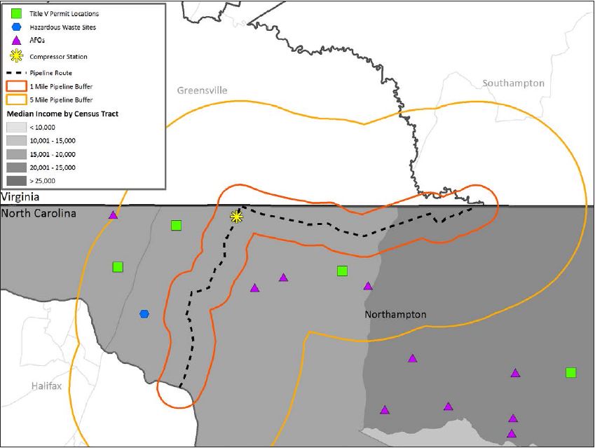
Figure A2.
23024Proposed pipeline route with selected facilities of interest and median income, by census tract, Robeson County
Source: US Census Bureau (2014): Table B06011; North Carolina Department of Environmental Quality (2016a, 2016b); North Carolina Division of Waste Management, Hazardous Waste Section (2016).
Appendix B
Table B1.
23015Northampton County aggregate income and household tallies, census tract data
Source: US Census Bureau (2014): Tables B19001 and B19025.
Table B2.
23016Northampton County aggregate income and household tallies, census block group data
Source: US Census Bureau (2014): Tables B19001 and B19025.
Table B3.
23017Robeson County aggregate income and household tallies, census tract data
Source: US Census Bureau (2014): Tables B19001 and B19025.
Table B4.
23018Robeson County aggregate income and household tallies, census block group data
Source: US Census Bureau (2014): Tables B19001 and B19025.
