Insights

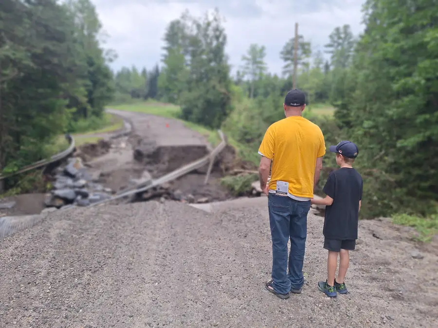
Figure 1. Road damage caused by heavy rain in July 2023, Lyndonville, Vermont.
The Toll of Extreme Weather on Infrastructure
One day in July 2023, it rained in Vermont. I was sitting at home with my husband and son when it started—a rainstorm so intense, it sounded like someone was hammering on our metal roof for what felt like an impossibly long time. Because it was late evening, we could not see what was happening outside. Soon, however, social media posts began painting a picture of the devastation as it was unfolding. In our small, rural corner of Vermont, people were sharing footage of roads, paved and unpaved, being carved away. In some cases, long-standing bridges and culverts gave way from the sheer force of moving water, cutting roads into pieces.
After the rain subsided the next morning, we ventured outside to survey the damage. Our road was completely impassable (Figure 1). It was riddled with huge holes and valleys and was washed away entirely in one location. A small, innocent-looking stream that was nonexistent in the minds of most who lived in the neighborhood had become a raging river overnight. The modest-sized culvert pipe that used to contain it under the road was now exposed, and the surrounding guardrails were mangled and intertwined with small trees and branches (Figure 2).
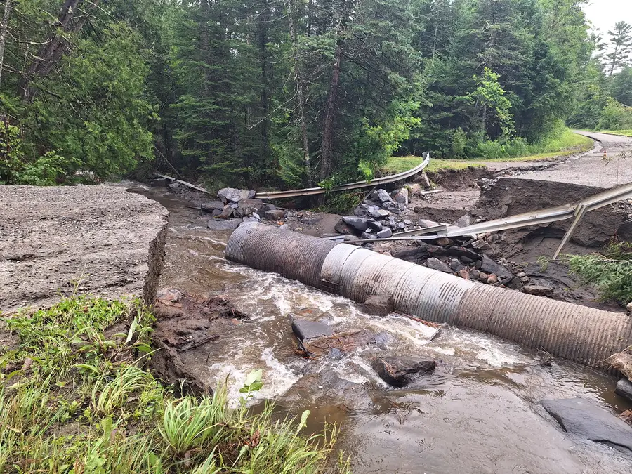
Figure 2. Exposed culvert pipe caused by heavy rain, Lyndonville, Vermont.
The damage was caused by about 4 inches of rain falling within a few hours overnight, on top of nearly 6 inches that had fallen the previous week. With the ground saturated and river levels already high, the water had nowhere else to go.
This was one of many extremely heavy rainfall events in Vermont that summer, many of which washed away roads, homes, and businesses. At one point, the entire capital city of Montpelier was underwater. During that summer of 2023, flooding in Vermont cost federal and local agencies more than $1 billion. Then, in 2024, our small town was hit again by extreme weather, resulting in floodwaters that destroyed more homes and bridges and took the lives of two people.
During this same year, Hurricane Helene produced record-breaking rainfall in Asheville, North Carolina, and surrounding areas, resulting in catastrophic destruction. Most devastating of all, hundreds of lives were lost. This was one of five billion-dollar tropical cyclones in the United States last year.
It is difficult to comprehend how much infrastructure we depend on each day and whether it is sufficiently designed to handle extreme weather events. Our roads, bridges, sewers, railways, dams, wastewater treatment plants, electrical grids, buildings, telecommunication equipment, pipelines, landfills, and parks must all be designed to withstand environmental hazards.
Designing Infrastructure to Withstand Extreme Weather
So, how can we build infrastructure that is resilient enough to withstand extreme weather? To make these decisions, we first need to know how likely it is for events of particular magnitudes to occur.
Information on precipitation frequency is available in the National Oceanic and Atmospheric Administration’s (NOAA’s) Atlas 14, the current authoritative extreme precipitation database. During that week in July 2023, about 10 inches of rain fell in Lyndonville, Vermont. According to NOAA Atlas 14, the probability of observing 10 inches within 1 week at this location during any given year is 1 in 1,000 or 0.1% (Figure 3).
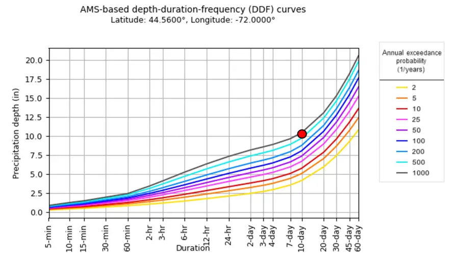
Figure 3. Probability of observing various precipitation amounts in central Vermont according to NOAA Atlas 14. The probability of observing 10 inches of precipitation within 1 week during any given year is about 1 in 1,000 or 0.1% (red dot). AMS stands for annual maximum series.
Based on this information, we might assume it would be safe to replace the damaged culvert pipe in my neighborhood with another that is the same size. After all, we should have another 999 years before we see an event of this magnitude again, right?
This argument has two fundamental flaws:
- A probability of 0.1% means that this type of event happens on average once every 1,000 years. But improbable does not mean impossible – rainfall of this extent could actually happen more than once within a few years.
- This probability is based on the assumption that climate and weather patterns are the same from one year to the next, but this is not the case.
For example, let’s consider total annual precipitation (rain and snow) that has been observed in the Northeastern United States since the start of the 20th century (Figure 4). The average annual precipitation during the most recent climatological period (1991–2020, dark grey horizontal line) is quite different from what was observed before then (1901–1990, light grey horizontal line). This is important because historical datasets are used in planning infrastructure for today and into the future.
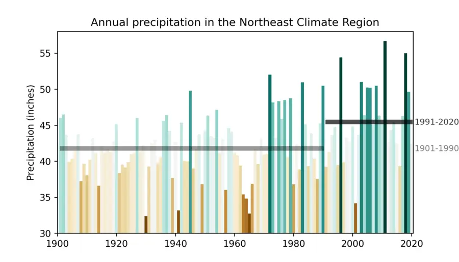
Figure 4. Annual precipitation for the Northeast Climate Region. Data obtained from NOAA National Centers for Environmental Information, Climate at a Glance: Regional Time Series, published January 2025. Horizontal lines represent the average precipitation over each time period.
Our climate and the resulting rainfall patterns are different from one year to the next, which is further illustrated in Figure 5. Climate normals, or 30-year precipitation averages, have shifted over time across the country. If we want national infrastructure that can withstand today’s extreme weather events, we need to account for this.
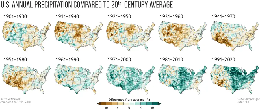
Figure 5. Precipitation climate normals based on 30-year averages. Image obtained from the National Weather Service. The National Center for Environmental Information updates these climatologies every 10 years to include the latest 30-year period.
Flood-Resilient Infrastructure Planning with NOAA Atlas 15
Currently, infrastructure planning across the United States is largely informed by NOAA Atlas 14, but some of this information is not based on the most recent precipitation data. In addition, NOAA Atlas 14 estimates are calculated based on an assumption that our climate is stationary over time, which is not the case.
NOAA Atlas 15, scheduled to be complete by 2027, will address these limitations. An extensive effort is underway to gather as much precipitation data as possible to produce a complete picture of probable precipitation depths across the nation. Novel methodologies have been developed for NOAA Atlas 15 that incorporate the best science, such as nonstationary statistical and dynamical modeling, to generate precipitation frequency estimates for present and future time periods.
NOAA Atlas 15 will contain up-to-date authoritative precipitation frequency estimates that will be used in the design of civil infrastructure across the country. It will contain precipitation depths for durations ranging from 5 minutes to 60 days and for events that happen frequently (once every few years) and less frequently (once every 1,000 years).
The ongoing development of NOAA Atlas 15 is made possible through an established collaboration among government, private industry, and academia. Upon completion, the data will be freely available on a high-resolution grid encompassing all 50 states and U.S. territories.
Although we do not know exactly when or where the next extreme storm will hit, the development of NOAA Atlas 15 will help municipalities better prepare their infrastructure for when it does. By ensuring that the design and maintenance of our infrastructure, like our small culvert pipe in rural Vermont, is informed by the most accurate information possible, NOAA Atlas 15 will reduce environmental and economic impacts and, most importantly, save lives.
Disclaimer: This piece was written by Janel Hanrahan (Hydroclimatologist) to share perspectives on a topic of interest. Expression of opinions within are those of the author or authors.